The Seneca Trail
“US Route 219, known in West Virginia as the Seneca Trail….
…Closely follows the section of the Warriors Road that crossed the State. The route traversed a region known in the early history of Virginia as West Augusta, which in the dark days of the Revolution is said to have inspired George Washington to say, “Leave me but a banner to plant upon the mountains of West Augusta, and I will gather around me the men who will lift our bleeding country from the dust and set her free.”-1941, The West Virginia Writers’ Project.
Traveling Route 219, one passes through scenery of local life rich with history. A hot dog stand from the 50s, a 19th century mill whose great wheel still grinds grain, a stone proclaiming the boundary of Lord Fairfax, small stands of virgin hemlock; these are places that point back in time. One comes to sense it: sections of this road are deeply worn.
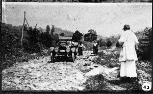
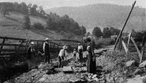
Building what is now US 219 between Linwood and Mace, W.Va.Courtesy of Pocahontas Preservation. PHS000043.
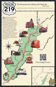
From its southern terminus at the New River in Rich Creek, Virginia, US Route 219 stretches 535 miles through Virginia, West Virginia, Maryland, Pennsylvania, and New York to its northern terminus in West Seneca, New York, ending at an interchange with Interstate 90 just shy of downtown Buffalo. Other than this short stint as a major city expressway, however, Route 219 generally keeps to smaller towns and rural scenery.
A spur of Route 19, Route 219 has been pieced together over the years from preexisting roads and bits of new construction. The section running through Maryland, still called the Garrett Highway, was constructed in the 1910s and 1920s as part of the original state road system. In 1926, when the highway numbering system came into effect, this bit of road was joined with the 200 miles of highway up through Pennsylvania to the New York state line to become the original Route 219. In 1934 this was extended 60 miles even further north to Hamburg, NY, near to its current northern terminus. Then, in 1937, Route 219 was extended south 270 miles to Princeton, WV.
The route it followed through West Virginia was an old one, and well-traveled. Long ago, it had been a major Indian footpath. The Seneca Trail, known also as the Great Indian War and Trading Path, was a part of a network of trails stretching from the Deep South to modern day New York that was used by the Catawba, various Algonquian tribes, the Cherokee, and the Iroquois Confederacy.
As European settlers began moving westward through this area, King George III drew a boundary in the Proclamation of 1763 that followed sections of the Seneca Trail. No settlers were to move west of this line. The explorers and pioneers could not be held back, however, and some of the roads left by their great westward push still intersect Route 219 today. Today’s US Route 60 approximates the James River and Kanawha Turnpike, a route proposed by a young surveyor named George Washington seeking to give Virginia access to trade in the West.
It was Thomas Jefferson who, in 1809, authorized the construction of the Cumberland, or National, Road. This road, the first major improved highway built by the US government, connected the Potomac and Ohio Rivers and further opened the settling of the West. The Northwestern Turnpike was completed at about this same time, and was one of the first major roads crossing the Appalachian Mountains. Today, U.S. 40 follows the same route as the National Road.
Shortly after the construction of the National Road, the Staunton-Parkersburg Turnpike (now US 250) was engineered through the steep terrain by Claudius Crozet in order to connect the upper Shenandoah Valley to the Ohio River.
The modern wayfarer may know nothing of this history as they zoom along Route 219. Yet they may find that they ease off the gas a little as they drive this mostly rural, scenic highway. This road has been traveled before, and a trip down it is meant to be savored.
–This article was written by Birch Graves.
sources:
Fansler, Homer Floyd. History of Tucker County. Parsons: McClain, 1962.
Maxwell, Hu. The Seneca Indian Trail. Magazine of History & Biography, (1954).
Rice, Donald L. “The Seneca Trail.” e-WV: The West Virginia Encyclopedia. 29 October 2010. Web. 17 February 2014.
Category: Elkins to Marlinton

